County Kilkenny Ireland
Antique Map - 1837
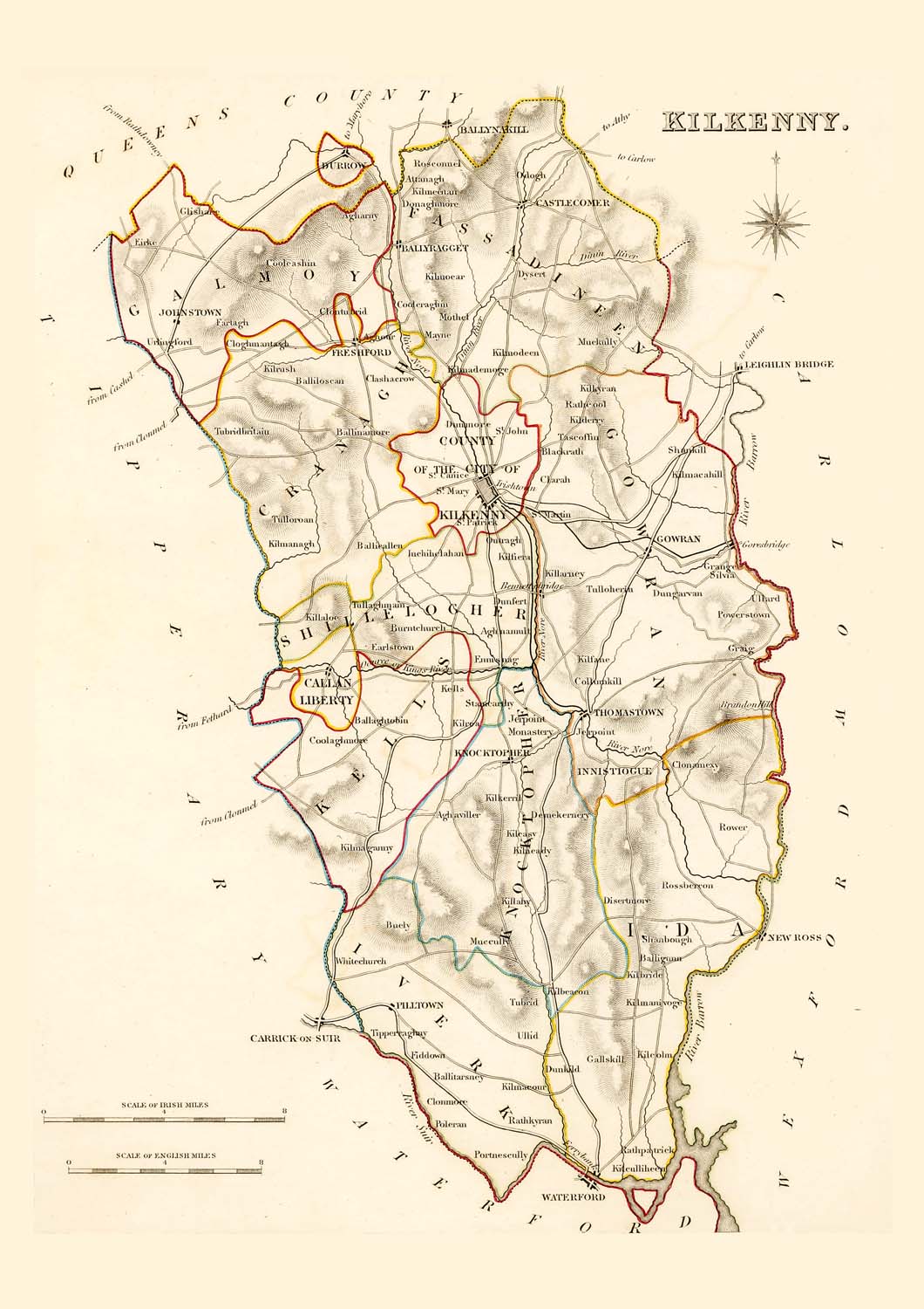
Free county Kilkenny map - this map can be copied from this page for free, it is 1500px along the longest edge. For a larger map to print out in fine detail at up to A4 size, please visit our partners at Etsy for a downloadable file.
![]()
Taken from: "Lewis's Atlas,
comprising the Counties of Ireland"
Published
in London by S. Lewis & Co. 87 Aldersgate Street 27th of
September 1837.
These maps are especially useful in genealogy as they were published in 1837, just 10 years before the disaster of the "Great Famine" in 1847. This was a time when the population size was at a historical high and just prior to the peak of Irish emigration as a result of the famine. The population of many places on the maps dropped rapidly in the following 20 years with some becoming uninhabited..
These maps are high resolution digital scans of the originals, the printed detail is greater than reproduced on this web site.
Original map image size is approx. 200 x 250mm
![]()
Buy a downloadable file of this map.
A high resolution digital scan of an original. These picture
files can be printed out at up to A4 size to give high
quality decorative prints for mounting and display.
The size and quality are optimized at 300dpi and 297mm x
210mm for a full size print which will fit in readily
available standard A4 picture frames.
For personal use only, not for resale or commercial use.
Places marked include:
Districts:
Galmoy, Fassadineen, Gowran, Shillelogher, County of the City of Kilkenny, Kells, Ida, Knocktopher, Iverk
Town, Villages, Settlements:
Agharny
Aghaviller
Aghnamult
Aghour
Attanagh
Baligunn
Ballaghtobin
Balliascan
Ballieallan
Ballinamore
Ballitarsney
Ballynagget
Ballynakill
Bennettsbridge
Blacknath
Buely
Burntchurch
Callan
Liberty
Castlecomer
Clarah
Clashcrow
Clogmantagh
Clonamexy
Clonmore
Clontubrid
Collumkill
Coolaghmore
Cooleashin
Cooleraghin
Demekernery
Disertmore
Donaghmore
Dunfert
Dungarvan
Dunkild
Dunmore
Dunnow
Dysert
Earlstown
Eirke
Ennisnag
Farlagh
Ferrybank
Fiddown
Freshford
Gallaskill
Glishare
Goresbridge
Gowran
Graig
Grange
Inchihelahan
Innistiogue
Irishtown
Jerpoint
Johnstown
Kells
Kihnoear
Kilbeacon
Kilbride
Kilcolm
Kilcullheen
Kilderry
Kilfane
Kilfiera
Kilkernil
Kilkyran
Killahy
Killaloe
Killarney
Kilmacahill
Kilmademage
Kilmaeour
Kilmagavny
Kilmanagh
Kilmanivoge
Kilmeenan
Kilmodeen
Kilneady
Kilnush
Kilroa
Knocktopher
Mayre
Mothel
Muccully
Muckully
Odogh
Outnagh
Pilltown
Poleran
Portnescully
Powerstown
Rathcool
Rathkyran
Rathpatrick
Roscornel
Rossbercon
Rowen
Shanbough
Shankill
Silvia
St. Canice
St. Martin
St. Mary
St. Patrick
Stamcarthy
Tascoffin
Thomastown
Tipperraghuy
Tubrid
Tubridbritain
Tullaghmain
Tulloherin
Tulloroan
Ullid
Ullord
Urlingford
Whitechurch
Other items with this map
 Standard Mug |
 Large Mug |
 Flask |
 Rectangle Magnet |
 Greeting Card |
 Greeting Cards (Pk of 10) |